

| What is LTBP? | |||||||||||||||||||||||||||||||||||||||||||||||||||||||||||||||||||||||||||
| Overview | |||||||||||||||||||||||||||||||||||||||||||||||||||||||||||||||||||||||||||
| Participants | |||||||||||||||||||||||||||||||||||||||||||||||||||||||||||||||||||||||||||
| Regional Offices | |||||||||||||||||||||||||||||||||||||||||||||||||||||||||||||||||||||||||||
| Features: | |||||||||||||||||||||||||||||||||||||||||||||||||||||||||||||||||||||||||||
| Calendar | |||||||||||||||||||||||||||||||||||||||||||||||||||||||||||||||||||||||||||
| Photo Gallery | |||||||||||||||||||||||||||||||||||||||||||||||||||||||||||||||||||||||||||
| Publications | |||||||||||||||||||||||||||||||||||||||||||||||||||||||||||||||||||||||||||
| Programmes: | |||||||||||||||||||||||||||||||||||||||||||||||||||||||||||||||||||||||||||
|
| Biodiversity |
| Environmental Edu. |
| Fishing Practices |
| Geogr. Info. Syst. |
| Help Desk |
| LARST |
| Newsletter |
| Metadata |
| Participants |
| Publications |
| Pollution |
| Sedimentation |
| Socio-economics |
| Training |
Processes: |
| Legal Convention |
| Strat. Action Prog. |
Management: |
| Reg. Co-ordination |
Projects: |
| Nyanza Course |
| Uvira Renovations |
| World Environ. Day |
Administration: | Project Resources | | ||||||||||||||||||||||||||||||
LARST Station
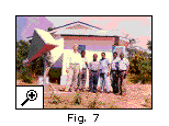 In 1997, a local capture system for the direct reception of daily NOAA Advanced Very High Resolution Radiometer (AVHRR) satellite data was established in Kigoma, Tanzania (Fig. 7). The regional scale data it creates (with a resolution of 1km pixels) can monitor vegetation status, lake and land surface temperature and fire ocurrence.
The following table describes the numbers of different images created (by successful acquisition) for a year August 1998- July 1999. The data have been used routinely in the Sedimentation study for modelling potential erosion rates in the catchment.
Figure 8 is taken from Kigoma station of a Channel 3 image (measuring thermal infrared reflectance, i.e. temperature related) for the region in June 1998. Note the large pale (cold) areas in the Malagarasi drainage where flooding is occurring, the other lakes in the region, and the Congo river in the west of the image. 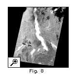 |
|| Home ||
