

| What is LTBP? | |||||||||||||||||||||||||||||||||||||||||||||||||||||||||||||||||||||||||||
| Overview | |||||||||||||||||||||||||||||||||||||||||||||||||||||||||||||||||||||||||||
| Participants | |||||||||||||||||||||||||||||||||||||||||||||||||||||||||||||||||||||||||||
| Regional Offices | |||||||||||||||||||||||||||||||||||||||||||||||||||||||||||||||||||||||||||
| Features: | |||||||||||||||||||||||||||||||||||||||||||||||||||||||||||||||||||||||||||
| Calendar | |||||||||||||||||||||||||||||||||||||||||||||||||||||||||||||||||||||||||||
| Photo Gallery | |||||||||||||||||||||||||||||||||||||||||||||||||||||||||||||||||||||||||||
| Publications | |||||||||||||||||||||||||||||||||||||||||||||||||||||||||||||||||||||||||||
| Programmes: | |||||||||||||||||||||||||||||||||||||||||||||||||||||||||||||||||||||||||||
|
| Biodiversity |
| Environmental Edu. |
| Fishing Practices |
| Geogr. Info. Syst. |
| Help Desk |
| LARST |
| Newsletter |
| Metadata |
| Participants |
| Publications |
| Pollution |
| Sedimentation |
| Socio-economics |
| Training |
Processes: |
| Legal Convention |
| Strat. Action Prog. |
Management: |
| Reg. Co-ordination |
Projects: |
| Nyanza Course |
| Uvira Renovations |
| World Environ. Day |
Administration: | Project Resources | | ||||||||||||||||||||||||||||||
|
The multidisciplinary, multinational and multiple challenges needed to comprehend the many facets of pollution and other effects on lake biodiversity create a complex web of information gathering and assessment. Much of this information inherently has a geographical aspect, and Geographical Information Systems (GIS) provide many of the tools to handle, store, visualise and work with this spatial data. The GIS component of the project was seen as a key resource for integrating geographical activity.
All the activities of the lake and the project are played out in geographical space, and the GIS allows integration of data by virtue of their shared locations. It has also allowed a picture of where project activity has been concentrated. The GIS has attempted to provide a framework for the future, a framework that allows for everybody to assist in gathering and collating new data, and have access to datasets produced by all. 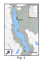
To this end, the GIS component has set out to create a logical framework for data storage and transferral across a wide geographical region. Over 400 items have been collected, both computer datasets and paper maps. A metadatabase has been developed within which all data can be documented. This is disseminated through the LTBP website in the form of data catalogues. The data themselves are available through a GIS interface based on a widely used software package, Arcview, which allows non-GIS users to get to the datasets quickly and efficiently. 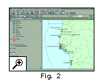 The datasets come from a wide range of sources, basic topographical map data are available, along with sizeable environmental and physical data such as land cover maps, bathymetry, and social and economic data (such as fishing boat surveys and population statistics. Project logistical data have been gathered, as the examples below show. The map (Fig. 1) shows an overview of where special study activities have occurred, the second (Fig. 2) showing in detail the work conducted in the Kigoma region. |
|| Home ||
| Next : Page 2 of 2 |
