

| What is LTBP? | |||||||||||||||||||||||||||||||||||||||||||||||||||||||||||||||||||||||||||
| Overview | |||||||||||||||||||||||||||||||||||||||||||||||||||||||||||||||||||||||||||
| Participants | |||||||||||||||||||||||||||||||||||||||||||||||||||||||||||||||||||||||||||
| Regional Offices | |||||||||||||||||||||||||||||||||||||||||||||||||||||||||||||||||||||||||||
| Features: | |||||||||||||||||||||||||||||||||||||||||||||||||||||||||||||||||||||||||||
| Calendar | |||||||||||||||||||||||||||||||||||||||||||||||||||||||||||||||||||||||||||
| Photo Gallery | |||||||||||||||||||||||||||||||||||||||||||||||||||||||||||||||||||||||||||
| Publications | |||||||||||||||||||||||||||||||||||||||||||||||||||||||||||||||||||||||||||
| Programmes: | |||||||||||||||||||||||||||||||||||||||||||||||||||||||||||||||||||||||||||
|
| Biodiversity |
| Environmental Edu. |
| Fishing Practices |
| Geogr. Info. Syst. |
| Help Desk |
| LARST |
| Newsletter |
| Metadata |
| Participants |
| Publications |
| Pollution |
| Sedimentation |
| Socio-economics |
| Training |
Processes: |
| Legal Convention |
| Strat. Action Prog. |
Management: |
| Reg. Co-ordination |
Projects: |
| Nyanza Course |
| Uvira Renovations |
| World Environ. Day |
Administration: | Project Resources | | ||||||||||||||||||||||||||||||
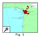 The major activities of the Special Studies have produced pertinent datasets for the GIS. For example, the Pollution study survey sites in Burundi (Fig. 3), to which monitoring data are easily attached and displayed, can be routinely passed to key decision-makers. The major activities of the Special Studies have produced pertinent datasets for the GIS. For example, the Pollution study survey sites in Burundi (Fig. 3), to which monitoring data are easily attached and displayed, can be routinely passed to key decision-makers.
The construction of the Survey and Literature Databases for the Biodiversity Special Study provide ample opportunity for integration into useful maps (Fig. 4). The link between these databases and the GIS means their use remains dynamic - as more survey data is integrated, the data is automatically updated in the GIS. 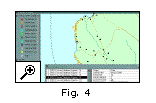
Finally, with datasets, supporting datasets have been created. We have made an extensive database of all placenames around the lakeshore in a gazetteer, and located the names of hundreds of settlements in the catchment (Fig. 5). In association with the development of the project spatial database, the GIS is encouraged to be integrated in with existing national environmental information networks in each country. 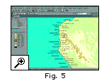 It should also assist in supporting the growing GIS community in the region, with more sharing of resources, training capability and expertise in projects. A GIS contacts database has been developed, which allows users to find who has what resources where. It should also assist in supporting the growing GIS community in the region, with more sharing of resources, training capability and expertise in projects. A GIS contacts database has been developed, which allows users to find who has what resources where.
Overall the GIS assists in the integration activities of the project, targeted towards providing one of the interfaces between scientists and the decision-makers. It makes people see how the pollution effects, fishing practices and sedimentation relate to the distribution and quality of biodiversity in the lakes, and gives an overwhelming sensation of the scale of the lake, is resources and interactions. 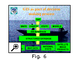
The GIS takes data from all the sources - Special Study data, map data, national statistics and satellite image products - and documents them within a structured database through the use of a metadatabase. The GIS interface can interact with that data producing the maps, charts, statistics and models which can support identified Strategic Action Programme activities (Fig. 6). |
|| Home ||
| Previous: Page 1 of 2 |
